Korea's typhoon center navigates storm predictions with more precision

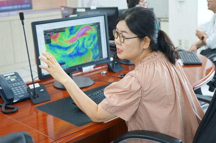
Typhoon forecaster Kim Dong-jin studies atmospheric movements over Southeast Asian waters at the National Typhoon Center on Jeju Island, Aug. 24. Courtesy of National Typhoon Center
With satellites and simulation models, climate data becomes more reliable
By Ko Dong-hwan
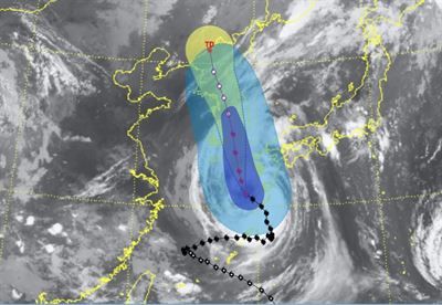
In this image generated by the National Typhoon Center before Typhoon Khanun hit the southern part of Korea, Aug. 10., Khanun was predicted to move over the Korean Peninsula putting both South and North Korea under its influence. Screen capture from Korea Meteorological Administration's website
SEOGWIPO, Jeju Island ― As Typhoon Khanun loomed over the Korean Peninsula on Aug. 10, the mood at the National Typhoon Center on Jeju Island was a mixture of tension and excitement. The center's meteorologists were meticulously analyzing data to forecast accurately the typhoon's path every three hours, while locals prepared for the potentially devastating impact of the storm.
Utilizing advanced simulation models, satellite data, current weather conditions and geographical information, a team of fewer than 20 experts at the center on the southern island was leaning toward a grim prediction ― Typhoon Khanun was likely to sweep through the entire country, including the capital region. Despite hoping that the typhoon would veer off its northward track and exit via the western coast before reaching Seoul, the evidence they had was concerning. The typhoon was set to affect the entire nation.
While the typhoon center's prediction was met with a consensus from other national institutions like radar and satellite centers, meteorological agencies in other technologically advanced countries such as the United States, Japan and China had different forecasts. They predicted that Khanun would deviate and exit through Korea's western coast before reaching the capital.
As it turned out, their forecasts failed were not correct. Khanun maintained its course, just 50 kilometers east of Seoul before continuing its northwestern trajectory, finally dissipating 80 kilometers southeast of Pyongyang.
One of the deputy directors at the National Typhoon Center, Park Jong-kyung, speaks while studying the movements of atmospheric pressure over Southeast Asian waters at the center in Jeju Island, Aug. 24. Courtesy of National Typhoon Center
Kim Dong-jin, a typhoon forecaster at the center, attributed their precise forecast to a wealth of data unavailable to other countries.
“We had more data to chew on than they did,” Kim told The Korea Times. “Of course, we share certain data with other countries so we can all use it. But because the data we (in Korea) get from our country's tight-knit weather forecast net is so tremendous in volume that we cannot share all of it.”
“There was this high-pressure area west of Korea that was firmly locked in position. There was another high-pressure system in the country's east. Other countries all thought this would influence the typhoon to shift west. But we had data that indicated to us that the west high-pressure system would withstand that nudge.”
From accuracy to preparedness
In the past, news reports in Korea focused on the predictive accuracy of weather agencies.
Officials at the Jeju typhoon center jokingly compared the conflicting typhoon predictions to an “international battle,” one that Korea seemed to win when it came to Khanun.
However, experts said that public interest in the "accuracy wars" has waned over the years. Kim pointed out that Korean media have shifted their focus from critiquing forecast accuracy to educating the public on how to minimize typhoon-related damage and casualties.
Lee Kyung-ho, the center's deputy director, noted that obsessing over the precision of forecasts is "meaningless."
“We predict and announce a typhoon's course given a certain error range,” Lee said. “Still today, our prediction course encompasses a range of 70 percent possibility. That means the typhoon can go anywhere within that range. So there's really no point in guessing and judging the exact route of a typhoon course. Besides, typhoons can further generate extreme downpours or storm surges during their progress, which more importantly, should be told to the public.”
Lee noted that once media coverage shifted from criticizing the center's forecasting abilities to educating the public on safety precautions, there was a significant decrease in typhoon-related casualties.
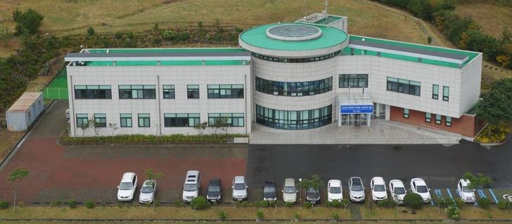
The National Typhoon Center in Seogwipo, Jeju Island / Courtesy of National Typhoon Center
Evolution of storm forecasting
The tracking of Khanun also provided new insights into the movement of typhoons through Korea's mountainous terrain.
Forecaster Kim said the center has learned something new from Khanun: how a typhoon moves within mountainous regions, a geography that dominates Korea. This lesson was particularly significant as Khanun was the first typhoon in decades to make landfall in the country and continue its course.
“It moves in a zigzag fashion between mountains. It never moves across them … We kept track of Khanun every hour. Its eye was disappearing and reappearing here and there as it was moving alongside the bases of mountains,” Kim said.
Established in 2008 after the country saw 376 people either dead or missing as well as sustained economic damage, worth over 9 trillion won ($6.8 billion) following Typhoon Maemi in 2003 and Rusa in 2002, the Jeju typhoon center has continuously improved its forecast accuracy.
Deputy Director Lee reminisced, “There were times when there was no internet and we had to receive typhoon forecasts from Japan via fax.”
“Meteorology is probably the world's most well-communicating field across the border as countries depend on data from not only their own but also other countries to understand each natural scene as a whole. It has always been.”
Today, the center boasts a forecast accuracy rate that has improved by nearly 50 percent compared to a decade ago. This advancement is largely due to state-of-the-art satellites and radars that feed data into computer systems, where forecasters diligently analyze the generated simulation models until confident enough to disseminate their predictions to the public.