Naver updates Dokdo images
By Kang Seung-woo
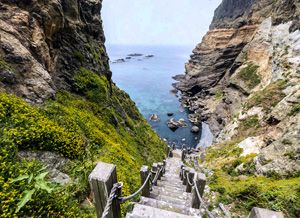
An updated image of Dokdo from Naver Maps
Naver, Korea’s dominant online portal, has updated photos of Dokdo on its maps service to mark the 72nd anniversary of the nation’s Liberation Day on Aug. 15.
Dokdo is the nation’s easternmost islet and is often a hot-button issue between Korea and Japan due to the latter’s continued claim to it.
The new photos, taken in July, include many of the latest views of Dokdo -- even underwater imagery and views of the rocky outcroppings around the islet, according to Naver.
“The photos were added so users can feel the scenic view of Dokdo and realize the true meaning of Liberation Day again," a Naver official said.
Naver’s online map service also allows users to see Dokdo’s changing landscape, comparing the updated images with those taken in 2011.
Starting with Dokdo, Naver plans to add updated photos of the nation’s other tourist attractions, including Jukdo Island in Boryeong, South Chungcheong Province, and Ulleung Island, North Gyeongsang Province, to its online map service on Aug. 24.
Dokdo has been the subject of a territorial dispute with Japan for years. Earlier, Tokyo announced the publication of its defense white paper for 2017 in which it claimed Dokdo is part of its territory.
It marks the 13th straight year Japan has laid claim to the rocky islet lying between the neighbors in their annual defense paper. Korea was under Japanese imperial rule from 1910 to 1945.
Japan’s claim to Dokdo has raised the ire of Koreans, who have suspicions Japan still does not regret its imperialistic past.
Currently, Dokdo is under strict control of Korea with armed policemen stationed there.